Drone Wildlife Surveys: 100x More Efficient Than Traditional Methods
Ground based wildlife surveying has always been slow, costly work. Teams on foot. Narrow search corridors. Hours spent in remote terrain after dark. And at the end of it, data that covers a fraction of the site, often when infrastructure planning, environmental approvals, and land management decisions hinge on knowing exactly what's there. Drone wildlife surveys are changing the economics and the outcomes of conservation work in Australia. Not incrementally but by orders of magnitude.
This article covers how aerial animal surveys work, what they have delivered on real projects, and why government agencies, land managers, and ecological consultants are making them a standard part of how they work.
The Limitation With Traditional Wildlife Surveying
Spotlighting has been the go-to method for nocturnal arboreal species surveys for decades. Walk a transect. Sweep a spotlight. Record what you find. It’s a well-established approach and remains effective in many situations, particularly for targeted surveys.
Camera traps can also play an important role, providing continuous monitoring at specific locations over time, specifically for ground based animals.
However, both methods are inherently focused on specific areas or points, which can make it difficult to build a site-wide picture, particularly across larger or more complex environments.
In practice, this can mean ground based surveys take days or weeks to build up coverage across an area. This leads to higher rates of error the longer the surveys proceed due to animal movements leading to under or over counting.
For ecological assessments and conservation programs where understanding species presence and distribution across an entire site is important, this can present a constraint, particularly in early-stage planning.
How Drone Wildlife Surveys Work
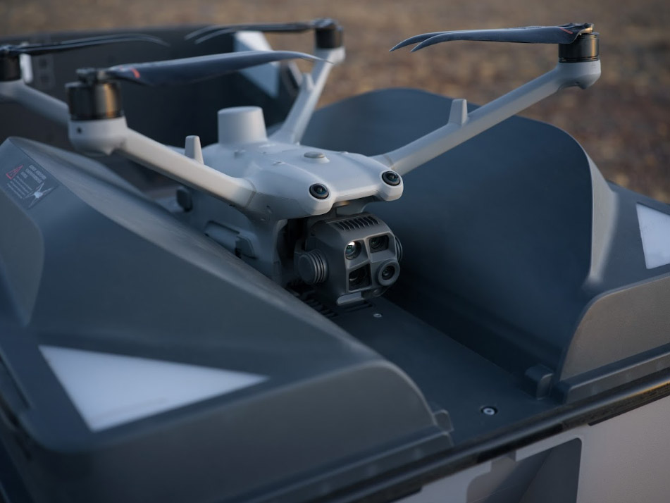
Field Master Systems conducts drone animal surveys using unmanned aerial systems fitted with thermal imaging cameras, high-resolution visual cameras, and LED spotlights. Thermal sensors pick up heat signatures from warm-blooded animals at night, across terrain that can be difficult to access, heavily vegetated, or unsafe for ground teams to cover on foot.
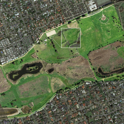
When a thermal detection is made, the visual camera and spotlight confirm the species. Every sighting is timestamped, georeferenced, and captured with photo and video evidence. The output is a precise, site-wide picture: mapped detection points, species counts, exact locations, and geospatial data ready for GIS and reporting workflows.
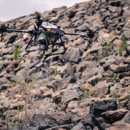
Where traditional spotlighting might cover a few hectares in a night, drone surveys routinely cover up to 100 hectares for arboreal mammal surveys and hundreds of hectares per night for open-terrain feral animal detection. That scale difference is where the 100x efficiency gain comes from. Same information. A fraction of the time and field effort.
Survey quality depends on planning, not just equipment. Field Master Systems uses pre-planned transect-based collection to achieve systematic, consistent coverage. Flight height and speed are matched to target species to ensure maximum accuracy. Detections are reviewed by experienced analysts, with qualified ecologist input for threatened or rare species.
Threatened Species Surveys: Where Drone Surveys Make the Biggest Difference
The primary application for drone wildlife surveys is threatened and endangered species detection, particularly for ecological assessments supporting infrastructure planning, land management decisions, and compliance obligations.
For arboreal mammals like Greater Gliders, Koalas, and Leadbeater's Possums, traditional spotlighting struggles with canopy cover and the scale of survey areas. Thermal drone surveys detect heat signatures through vegetation at night, across the full survey area, in a fraction of the time. Every detection is mapped with an exact GPS location and photographic evidence, producing data that can be referenced directly in ecological reports, environmental impact assessments, and planning submissions.
Threatened Species Surveys for Road Infrastructure, Cardinia Shire Council
Cardinia Shire Council needed accurate species data for a proposed road upgrade corridor before works could proceed. Multiple nocturnal species were expected to be present in roadside vegetation. Ground-based spotlighting could not cover the full corridor efficiently or safely at night.
Field Master Systems deployed thermal drones along the corridor, surveying several kilometres of roadside vegetation in a single night. Plenty of native animals were documented with photo, video, and GPS coordinates, including endangered Greater Gliders. Each detection carried a mapped location and photographic record.
Cardinia's project ecologists used this data to guide road design directly, identifying habitat trees for protection and developing species management programs referenced throughout the project lifecycle.
"Using FMS technology and methodology, ecologists have accurately identified endangered species and have made a major contribution to the design of these roads and the establishment of species management programs." Peter, Cardinia Shire.
Read the full Cardinia Shire threatened species survey case study.
Endangered Animal Surveys for Timber Harvesting, VicForests
Timber harvesting operations in native bushland historically required pre-operational fauna assessments to identify and protect endangered species. Field Master Systems conducted endangered animal surveys for VicForests across remote native bushland, with the specific purpose of identifying Greater Glider and Yellow-Belly Glider presence so habitat could be protected from harvesting. Surveys that would have taken weeks on foot were completed in a fraction of the time, with more comprehensive coverage and verifiable evidence for each detection.
Read the full VicForests endangered animal survey case study.
Southern Greater Glider Surveys for Fuel Reduction Burns
Before a fuel reduction burn proceeds, agencies need to understand what endangered species are living in the proposed burn area. Southern Greater Gliders and Yellow-Belly Gliders often inhabit the native forest targeted for burns. Traditional spotlighting is unlikely to cover an entire burn unit, and sending surveyors into steep remote terrain at night carries real operational risk.
Field Master Systems conducted drone surveys across proposed burn units. In one survey, more than 100 Southern Greater Gliders were positively identified within a 94 hectare area in a single night. Population counts, exact locations, and photographic evidence for each sighting were delivered to the responsible government agency to inform burn decisions and support ongoing species management obligations.
Feral Animal Detection
Beyond threatened species work, drone surveys are also used for feral animal population monitoring, where the ability to cover large areas quickly and produce precise location data supports baiting programs and pest control operations.
Feral Pig Detection, Gippsland, DEECA
The Department of Energy, Environment and Climate Action needed accurate feral pig population data across bushfire-affected areas of Gippsland to guide baiting programs. Trail cameras can confirm presence at specific locations but are prone to double counting and missing nearby animals entirely, making reliable population estimates across a large area difficult to achieve.
Field Master Systems worked with DEECA to develop a drone survey methodology for feral pig detection. Thermal camera-equipped drones mapped pig locations precisely across thousands of hectares per week, generating reports that guided baiting decisions and provided measurable program outcomes.
Read the full Gippsland feral pig detection case study.
When Drone Wildlife Surveys Work Best
Season matters. Thermal surveys perform best in cooler conditions when the contrast between animal heat signatures and ambient temperature is highest. In south-eastern Australia, late autumn through spring is the optimal window for most species. Summer surveys are still possible on cool nights but require careful planning.
Flight height and speed are matched to target species. Lower, slower flight improves detection accuracy for small species and those using tree hollows, but reduces the area covered per night. Field Master Systems adjusts flight parameters for each survey based on the target species and site conditions to achieve the best balance of coverage and maximum detection rate.
For steep, remote, or hazardous terrain, drones remove the need to physically access survey sites at night, which matters for both safety management and survey practicality.
Data That Supports Real Decisions
Every Field Master Systems drone wildlife survey produces outputs built for practical use: timestamped, georeferenced photo and video records of each detection; mapped detection points with species and count data; geospatial files compatible with GIS and planning workflows; and summary documentation structured for compliance and reporting.
This is not data collected for its own sake. It is evidence that ecologists, land managers, and government agencies can use it to make decisions, defend those decisions, and demonstrate due diligence when it matters.
Field Master Systems works with government agencies, land managers, ecological consultants, and conservation organisations across Victoria, New South Wales, and Queensland. Get in touch to discuss your survey requirements.
Frequently Asked Questions
Are drone wildlife surveys more accurate than spotlighting?
For nocturnal species across large or complex sites, drone thermal surveys can produce higher detection rates than spotlighting in certain conditions, particularly across larger or more complex sites. Spotlighting is limited by what surveyors can physically access and illuminate. Thermal detection picks up heat signatures across the entire survey footprint, including areas that would be missed or unsafe to survey on foot. Detection rates vary by species, flight parameters, and conditions.
Can thermal drones detect small mammals?
Yes, though detection rates for small species depend on flight height, speed, ambient temperature, and vegetation density. Field Master Systems adjusts flight parameters specifically for target species. For small arboreal mammals such as Feathertail Gliders and Sugar Gliders, lower and slower flight improves detection accuracy. Every survey methodology is designed around the target species to maximise detection rates.
Can thermal drones detect animals in tree hollows?
Thermal imaging can detect heat signatures at hollow entrances when animals are present near the opening. Detection of animals fully inside deep hollows is limited by the insulating effect of the tree. Field Master Systems can discuss the capabilities and limitations for specific target species and hollow types when scoping a survey.
What species can drone thermal surveys detect?
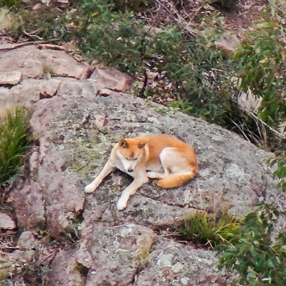
Field Master Systems drone surveys can detect a wide range of native and introduced species including Greater Gliders, Yellow-Belly Gliders, Feathertail Gliders, Sugar Gliders, Leadbeater's Possums, Koalas, feral cats, feral dogs, pigs, deer, foxes, and rabbits. Species are confirmed using thermal detection combined with a zoom visual camera and LED spotlight where required.
How are drone surveys used in infrastructure and planning projects?
Drone surveys are used for pre-construction fauna assessments to identify threatened and endangered species before infrastructure works begin. The data supports environmental impact assessments, planning submissions, and species management programs. Field Master Systems conducted threatened species surveys for Cardinia Shire Council ahead of road upgrade works, delivering site-wide species data that guided road design and habitat tree protection decisions directly.
How much do drone wildlife surveys cost and how are they scoped?
Survey costs depend on site size, target species, terrain, location, and reporting requirements. Field Master Systems scopes each survey around the specific project objectives, calculating time based on area, access, and methodology. Get in touch to discuss your requirements and receive a scoping estimate.
Do drones disturb wildlife during surveys?
Most animals do not show significant behavioural change when a drone is observing from survey altitude. For more sensitive species, Field Master Systems maintains appropriate distances to minimise disturbance. Non-invasive surveying is a core part of the methodology on every mission.