

Transform Modern Farming With Agricultural Drone Services
Unlock smarter farm management with advanced agricultural drone services built for today’s growers. From crop monitoring and precision spraying to detailed mapping and livestock tracking, our farm drones deliver real time data that supports faster decisions, stronger yields and lower operating costs.
Request a QuoteAdvanced Agricultural Drone Services
Smarter farming starts with accurate data and precise aerial delivery. Our agricultural drone solutions support growers, agribusinesses, and land managers with efficient, cost effective tools designed for modern Australian conditions.
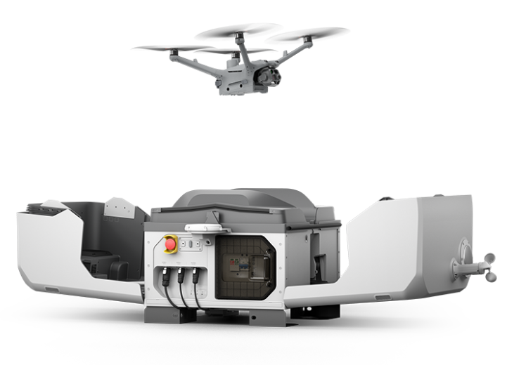
Drone in a Box: The DJI Dock 3 and How it's Changing Agriculture
See how the new DJI Dock 3 is allowing agricultural businesses to save time and money with autonomous operations.
Agricultural Drone Services
Explore our full range of Agricultural Drone Services that we provide here at Field Master Systems.
Crop Health Monitoring
Using agricultural drone mapping and multispectral imaging, we help identify crop stress, disease and nutrient deficiencies early. This approach supports fruit orchards, vegetable growers and large scale commodity crops such as wheat, canola, rice, corn and sugarcane by enabling targeted responses before yield is impacted.
Precision Weed Control
Agricultural drone spraying allows targeted weed treatment across paddocks, orchard rows and hard to access areas, reducing chemical use while improving coverage. This service is commonly applied across broadacre cropping systems, dairy farms and mixed farming operations.
Drone Seeding
Aerial seeding supports large scale revegetation and crop preparation by distributing seed evenly across prepared land. This method is well suited to rehabilitation areas, rotational cropping land and properties managing soil recovery.
Fertiliser Application
Farm drone application enables precise fertiliser placement across crops and pasture, improving nutrient efficiency and reducing runoff. This is particularly effective for intensive cropping systems and pasture management for dairy and livestock farms.
Field and Paddock Mapping
High-resolution agricultural drone mapping delivers accurate terrain and vegetation data to support planning, irrigation design and land management. This service is used across large scale cropping properties, orchards and mixed farming enterprises.
Livestock Monitoring
Farm drones support efficient monitoring of sheep, cattle and poultry operations by observing stock movement, water access and fencing conditions. Aerial animal survey techniques reduce time spent on ground checks while supporting animal welfare and property management.


"Goulburn Murray Water have really valued working with the guys at Field Master Systems. This has helped us look at ways we can utilise drones to improve our efficiencies in our everyday spray operations. Regardless of differing weed types in varying terrains/situations they have been able to adapt the drone spraying to work efficiently and effectively."
Danielle, GM Water
From Aircraft Pilot to Drone Pilot
Built For Smarter And More Sustainable Farming
Precision Where It Matters
Our agricultural drone technology delivers accurate spraying, mapping and crop data so every hectare receives the right treatment at the right time.
Reduced Operating Costs
Farm drone services lower labour, fuel and chemical use by replacing manual fieldwork with targeted, automated aerial operations.
Faster Decision Making
High-resolution aerial data and farm drone insights give you a clear picture of crop health, land condition and livestock movement without delays.
Environmentally Responsible
Targeted agricultural drone application reduces runoff, overspray and waste, supporting more sustainable land and crop management.

Licences and Qualifications
Our commitment to excellence is reflected in our team’s extensive qualifications and licences, ensuring that we adhere to the highest industry standards. You can trust Field Master Systems to deliver agricultural drone services backed by proven expertise and industry credentials.
BVLOS (Beyond Visual Line Of Sight)
EVLOS (Extended Visual Line Of Sight)
Fixed Wing <7kg
Powered Lift – Medium Category
Get Expert Support For Your Farm, From The Ground Up
Work with Field Master Systems to bring precision, efficiency and reliability to every hectare. From agricultural drone mapping to targeted spraying and seeding, our team delivers smarter aerial solutions built for Australian conditions. Request your tailored quote today.
FAQ
Discover answers to common queries about our drone services and solutions. Explore how our expertise can benefit your projects and operations.
Agricultural drones collect aerial data for crop monitoring, field mapping and targeted spraying of fertilisers, herbicides and pesticides. They help improve operational efficiency, detect stress early and support precision agriculture decision-making.
You only need a licence if the drone weighs more than 25 kg on your own property, or more than 2 kg when operating on someone else’s property.
Yes. Drones reduce manual labour, enable precise chemical application and lower fuel and input costs by targeting only areas that need treatment. This leads to more efficient resource use and long-term savings.
Modern agricultural drones with GPS/RTK systems can deliver centimetre-level mapping accuracy and highly precise spraying, ensuring consistent coverage and detailed field insights.
Drones capture high-resolution RGB imagery, multispectral, LiDAR and thermal data that reveal crop health, soil moisture, pest pressure and irrigation needs, helping guide decisions for fertiliser, water and crop protection.
Yes , when operated responsibly and at appropriate distances, drones can be used safely around livestock. However, spraying should be carefully planned, as some herbicides have withholding periods and should not be applied near animals. Trained operators account for chemical safety, wind conditions, and livestock proximity to minimise stress, exposure, or disturbance.
Absolutely. Agricultural drones excel in areas that are hard to reach with tractors or ground equipment, such as steep slopes, wet paddocks or uneven ground, improving coverage and safety.
Yes. Precision spraying reduces overspray and chemical waste, minimises runoff and supports more sustainable application of pesticides and fertilisers.